![](/images/other/stat-length.png)
![Randonnée A pied Villeneuve (VD) - Les Grangettes - Photo](https://media.geolcdn.com/t/1900/400/ext.pjpeg?maxdim=2&url=https%3A%2F%2Fstatic1.geolcdn.com%2Fsiteimages%2Fupload%2Ffiles%2F1545311037marcheuse_200dpi.jpg)
Les Grangettes
famiski
Utilisateur
![Longueur](/images/other/stat-length.png)
Longueur
8,2 km
![Altitude max](https://static1.geolcdn.com/siteimages/upload/files/1508320355ic_sort_altitude_max_24dp.png)
Altitude max
385 m
![Dénivelé positif](https://static1.geolcdn.com/siteimages/upload/files/1508320355ic_sort_den_pos_24dp.png)
Dénivelé positif
56 m
![Km-Effort](/images/other/stat-length.png)
Km-Effort
9 km
![Altitude min](https://static1.geolcdn.com/siteimages/upload/files/1508320355ic_sort_altitude_min_24dp.png)
Altitude min
371 m
![Dénivelé négatif](https://static1.geolcdn.com/siteimages/upload/files/1508320355ic_sort_den_neg_24dp.png)
Dénivelé négatif
57 m
![Boucle](https://static1.geolcdn.com/siteimages/upload/files/16400158638029165_repeat_loop_refresh_sync_direction_icon.png)
Boucle
Oui
Date de création :
2023-03-24 09:36:53.36
Dernière modification :
2023-03-24 09:37:12.342
![A pied](https://static1.geolcdn.com/sitytour/trail-icons/100.png)
2h02
Difficulté : Facile
![Scannez ce code QR pour ouvrir la randonnée dans l'application SityTrail](https://capi.geolives.com/qq0zvz2zws4bq2lad0pu/sitytour/trails/3595792/qr.png?size=200)
Application GPS de randonnée GRATUITE
À propos
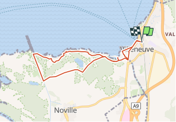
Randonnée A pied de 8,2 km à découvrir à Vaud, District d'Aigle, Villeneuve (VD). Cette randonnée est proposée par famiski.
Description
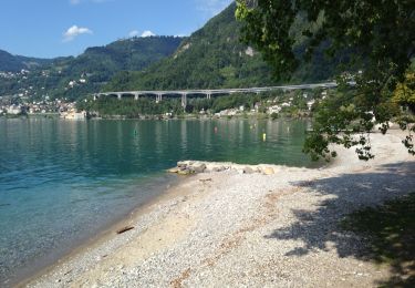
La promenade commence à gare de Villeneuve pour ensuite longer le lac en direction de la réserve naturelle des Grangettes. Vous traverserez le magnifique jardin instinctif et profiterez d'une splendide vue sur le lac Léman.
Localisation
Pays :
Suisse
Région :
Vaud
Département/Province :
District d'Aigle
Commune :
Villeneuve (VD)
Localité :
Unknown
Départ:(Dec)
Départ:(UTM)
340598 ; 5140391 (32T) N.
Commentaires
Randonnées à proximité
![Randonnée Marche Montreux - Montreux - Villeneuve - Le Bouveret - Photo](https://media.geolcdn.com/t/375/260/ext.jpg?maxdim=2&url=https%3A%2F%2Fstatic1.geolcdn.com%2Fsiteimages%2Fupload%2Ffiles%2F1553511878bg_sport_marche.png)
![Marche Marche](https://static1.geolcdn.com/sitytour/trail-icons/101.png)
Montreux - Villeneuve - Le Bouveret
Marche
Très facile
(1)
Montreux,
Vaud,
District de la Riviera-Pays-d’Enhaut,
Suisse
![](/images/other/stat-length.png)
14,5 km | 16,4 km-effort
Inconnu
![](https://static1.geolcdn.com/siteimages/upload/files/16400158638029165_repeat_loop_refresh_sync_direction_icon.png)
Non
![Randonnée Marche Villeneuve (VD) - Bois de Chillon - Photo](https://media.geolcdn.com/t/375/260/ext.jpg?maxdim=2&url=https%3A%2F%2Fservices.sitytrail.com%2FGeolivesWS%2FDownloadMedia.ashx%3FTrailID%3D470065%26Media%3D20150908161735.jpg)
![Marche Marche](https://static1.geolcdn.com/sitytour/trail-icons/101.png)
Bois de Chillon
Marche
Facile
Villeneuve (VD),
Vaud,
District d'Aigle,
Suisse
![](/images/other/stat-length.png)
10,6 km | 16,1 km-effort
2h 30min
![](https://static1.geolcdn.com/siteimages/upload/files/16400158638029165_repeat_loop_refresh_sync_direction_icon.png)
Oui
![Randonnée Vélo Villeneuve (VD) - Coteaux du Chablais - Berge du Rhõne - Photo](https://media.geolcdn.com/t/375/260/ext.jpg?maxdim=2&url=https%3A%2F%2Fservices.sitytrail.com%2FGeolivesWS%2FDownloadMedia.ashx%3FTrailID%3D461969%26Media%3D20150821110429.jpg)
![Vélo Vélo](https://static1.geolcdn.com/sitytour/trail-icons/200.png)
Coteaux du Chablais - Berge du Rhõne
Vélo
Moyen
Villeneuve (VD),
Vaud,
District d'Aigle,
Suisse
![](/images/other/stat-length.png)
50 km | 59 km-effort
2h 24min
![](https://static1.geolcdn.com/siteimages/upload/files/16400158638029165_repeat_loop_refresh_sync_direction_icon.png)
Non
![Randonnée Marche Roche (VD) - Boucle d Arvel Joux Verte - Photo](https://media.geolcdn.com/t/375/260/ext.jpg?maxdim=2&url=https%3A%2F%2Fservices.sitytrail.com%2FGeolivesWS%2FDownloadMedia.ashx%3FTrailID%3D264798%26Media%3Dfix__20140409134802.jpg)
![Marche Marche](https://static1.geolcdn.com/sitytour/trail-icons/101.png)
Boucle d Arvel Joux Verte
Marche
Moyen
Roche (VD),
Vaud,
District d'Aigle,
Suisse
![](/images/other/stat-length.png)
6,9 km | 18,7 km-effort
1h 44min
![](https://static1.geolcdn.com/siteimages/upload/files/16400158638029165_repeat_loop_refresh_sync_direction_icon.png)
Oui
![Randonnée Marche Veytaux - st_Rochers-de-Naye - Photo](https://media.geolcdn.com/t/375/260/ext.jpg?maxdim=2&url=https%3A%2F%2Fstatic1.geolcdn.com%2Fsiteimages%2Fupload%2Ffiles%2F1553511878bg_sport_marche.png)
![Marche Marche](https://static1.geolcdn.com/sitytour/trail-icons/101.png)
st_Rochers-de-Naye
Marche
Très facile
Veytaux,
Vaud,
District de la Riviera-Pays-d’Enhaut,
Suisse
![](/images/other/stat-length.png)
6,4 km | 11,1 km-effort
1h 42min
![](https://static1.geolcdn.com/siteimages/upload/files/16400158638029165_repeat_loop_refresh_sync_direction_icon.png)
Non
![Randonnée Marche Montreux - Dent de Jaman - Rochers - de Naye - Photo](https://media.geolcdn.com/t/375/260/ext.jpg?maxdim=2&url=https%3A%2F%2Fstatic1.geolcdn.com%2Fsiteimages%2Fupload%2Ffiles%2F1553511878bg_sport_marche.png)
![Marche Marche](https://static1.geolcdn.com/sitytour/trail-icons/101.png)
Dent de Jaman - Rochers - de Naye
Marche
Très facile
(1)
Montreux,
Vaud,
District de la Riviera-Pays-d’Enhaut,
Suisse
![](/images/other/stat-length.png)
3,4 km | 6,6 km-effort
Inconnu
![](https://static1.geolcdn.com/siteimages/upload/files/16400158638029165_repeat_loop_refresh_sync_direction_icon.png)
Non
![Randonnée Marche Montreux - Rando Caux Jaman Nayes - Photo](https://media.geolcdn.com/t/375/260/ext.jpg?maxdim=2&url=https%3A%2F%2Fstatic1.geolcdn.com%2Fsiteimages%2Fupload%2Ffiles%2F1553511878bg_sport_marche.png)
![Marche Marche](https://static1.geolcdn.com/sitytour/trail-icons/101.png)
Rando Caux Jaman Nayes
Marche
Difficile
Montreux,
Vaud,
District de la Riviera-Pays-d’Enhaut,
Suisse
![](/images/other/stat-length.png)
15,8 km | 29 km-effort
4h 17min
![](https://static1.geolcdn.com/siteimages/upload/files/16400158638029165_repeat_loop_refresh_sync_direction_icon.png)
Oui
![Randonnée A pied Montreux - Les Gorges du Chauderon - Photo](https://media.geolcdn.com/t/375/260/ext.jpg?maxdim=2&url=https%3A%2F%2Fstatic1.geolcdn.com%2Fsiteimages%2Fupload%2Ffiles%2F1545311037marcheuse_200dpi.jpg)
![A pied A pied](https://static1.geolcdn.com/sitytour/trail-icons/100.png)
Les Gorges du Chauderon
A pied
Facile
Montreux,
Vaud,
District de la Riviera-Pays-d’Enhaut,
Suisse
![](/images/other/stat-length.png)
6,7 km | 11,8 km-effort
2h 40min
![](https://static1.geolcdn.com/siteimages/upload/files/16400158638029165_repeat_loop_refresh_sync_direction_icon.png)
Oui
![Randonnée A pied Montreux - Itinéraire course à pied / marche : Boucle Hauts-de-Caux - Sonchaux - Photo](https://media.geolcdn.com/t/375/260/ext.jpg?maxdim=2&url=https%3A%2F%2Fstatic1.geolcdn.com%2Fsiteimages%2Fupload%2Ffiles%2F1545311037marcheuse_200dpi.jpg)
![A pied A pied](https://static1.geolcdn.com/sitytour/trail-icons/100.png)
Itinéraire course à pied / marche : Boucle Hauts-de-Caux - Sonchaux
A pied
Facile
Montreux,
Vaud,
District de la Riviera-Pays-d’Enhaut,
Suisse
![](/images/other/stat-length.png)
9,8 km | 15,4 km-effort
3h 30min
![](https://static1.geolcdn.com/siteimages/upload/files/16400158638029165_repeat_loop_refresh_sync_direction_icon.png)
Oui